|
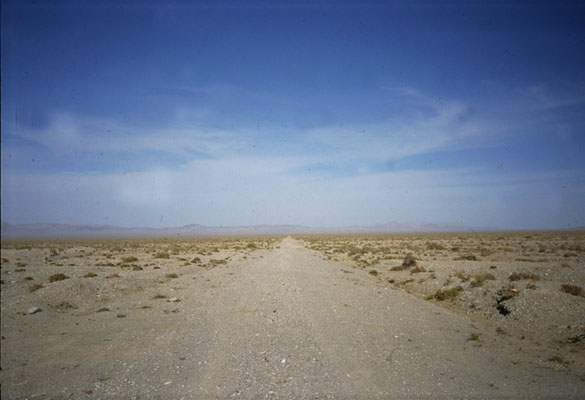
Day 60 Left Dunhuang. Everything is desert. No trouble from the police; no police at all. Under a full moon, cycled into the night expecting to reach turnoff for 313. By nine at night we spot the tattered sign: "313 -- Anxi to Ruoqiang." At this junction there is a truck stop, and we stop for noodles, then set off down 313. Less than a kilometre down the road stood a guard post with a barricade. We could see a couple of guards inside their booth chatting, not paying attention. Taking a chance, we skirt quickly under the barricade hoping no one would notice. They didn't. The road is earthen. We decide to put a few kilometres between us and the guard booth. We drag the bikes off the road and push them along a shallow ditch a hundred metres, finding a nice patch of soft sand to sleep on. We unfurl the bags and get some shut-eye. |
 |
|
 |
Day 61 With daylight, we can see the details of our desert surrounding. Pack up our camp and push the bikes back to the road and head west. According to the map, we will have to travel 40 kilometres to reach the first town; that will be our lunch. No breakfast today. Along the way, a handful of dump trucks pass us; we speculate they're carrying ore from mines in the mountains ahead. Other than that, the place is completely desolate. The going is slow on this road, and a little tough on the ass with the constant bumping and jolting. The bikes have front suspension forks, which absorb every hit the road can deliver, leaving us to bash down the road at a fast clip despite the rocky, undulating surface. I pledge my next bicycle adventure will be on a full-suspension bike. |
By noon, we catch sight of some kind of small building along the road in the distance, guessing it must be the town on the map. We arrive at it only to find a storage house for ore and coal. A man there examines our map and tells us to continue west to reach the town.
By three o'clock we've traveled seventy kilometres and no sight of any town. The road is occasionally severed by washouts. To our left -- south -- are the Qilian and Altun mountains, beyond them the Tibetan Plateau. To our right is a smaller chain of mountains. Somewhere ahead is the Lop Nor Desert, China's nuclear weapons testing area.
We feel extremely frustrated with our condition. Why hadn't there been a town? Each of our maps said there would be one just 40 kilometres down this road, and we'd already come over seventy kilometres.
If the maps aren't right about this town, will they be right about anything ahead? Can we afford to count on them? We haven't seen a single truck since the storage house; they apparently go elsewhere.
We'd come a long distance and still not had a meal. By this point in the ride, both of us were pretty lean. Cycling over 4,000 kilometres will do that to a person. That length of training also results in some seriously efficient leg muscles. Even the smallest morsel of calories could be translated directly into power.
But that notwithstanding, we were hungry. And one of us has a metabolism from hell. Calories are key. Dipping into our snack provisions and water, we consider our options: forward into uncertainty or back to the truck stop at the turnoff for 313.
We chalk the absence of the town up to a glitch in the map and decide to continue, convinced that we'll come to a town, even if it takes until tomorrow. By 3 o'clock we catch sight of a slight oddity in the landscape along the foot of the mountains to our right -- north. As we get closer and closer, we discover the oddity is in fact a grove of trees. "That can only be one thing," we conclude.
"An oasis!"
Sure enough, approaching the area, we see a truck heading up from the oasis to meet the road we're on. Ecstatic, we wait for him and drill him with questions. He explains that the route we're on is no longer used as a route into Xinjiang. People go through Aksay in Qinghai Province. He advises us to forget about 313 and go back east and then south to Aksay and from there, west towards Xinjiang.
But we want to know about 313 -- what's ahead? "There's no road!" he says over and over.
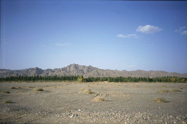
We part ways with him and head down to the oasis, 15 kilometres off the main road. It is kept alive by an irrigation ditch carrying water across the desert from the Qilian Mountains to the south. The oasis is a commune of about 300 people, with a kitchen and store and a couple of extra rooms for visitors.
We have dinner in the kitchen and learn more about the road west: another 70 kilometres west will be a turnoff for an oasis called Nan An Ban, 21 kilometres off the road. Nan An Ban is in the Qilian Mountains and it is a Kazakh village. It is near the border with Xinjiang, and it is the last village on 313; west of it the road disappears.
With this in mind, we decide to at least cycle to that village and then make a final decision about 313 based on the information we get from people in Nan An Ban. At night we visit the store and relive it of canned meat, dried instant noodle, lots of candy and some other delicacies in preparation for tomorrow's ride to the border of Xinjiang.
Day 62
October 9, 1995
Just as they'd told us, there was nothing out here. We cycled all morning and took a break for lunch. A truck came along and we flagged it down to see who it was and ask them some questions. The driver and his passengers got out for a chat with us. They spoke an unintelligible Central Asian language, and their features were more like my own than like Chinese: they were Kazakh.
Yes! We finally felt like we were in Central Asia. We cycled all afternoon and discussed our situation. Although everyone so far had told us not to continue west on this road, we were inclined to talk ourselves into it. One reason was the police: out here on this abandoned route, we knew we could cycle well into Xinjiang without the slightest possibility of being arrested or hassled in any way.
During the first couple thousand kilometres of our journey, we'd had several run-ins with the cops because we'd cycled in areas closed to foreigners, although we had no way of knowing so. After paying several hundred dollars in cumulative fines and enduring "house arrests" and hair-raising midnight runs from the cops, we'd learned to be extra cautious about the police, and we'd learned how to avoid them: we'd made it all the way through Gansu Province without a single run-in with the men in green.
Another reason for continuing in this direction was time: it was already mid-October and we had over a thousand kilometres to go to reach our destination, Kashgar. That meant weather was closing in on us, not to mention the expiry of my visa and my partner's date with a Fulbright fellowship in December.
So there were reasons to go forward, but how to rationalize it? No problem -- if you want to do something, you can come up with plenty of reasons why it's possible. We figured we could go for three days on one supply of food and water. If the road absolutely turned to sand, we could push the bikes through it for an entire day if need be. Our success thus far in the journey across the mainland of China was a two-sided coin.
On one hand, it hardened us in a big way; we were disciplined in the extreme and ready to look adversity in the face. But that confidence made us cocky and liable to overestimate our own abilities. Another way to rationalize contradicting the message everyone was giving us was to belittle the messengers. "They simply don't go that direction," we said. "So they really don't know what's out there."
In fact, in order to succeed in the journey thus far, we'd had to make it a rule to take people's warnings with a grain of salt. If we'd listened to every person who said we couldn't get somewhere or take a particular route, we never would have made it this far. That's for sure. So, we decided the same rule should hold in this case. Granted, the stakes were a little higher.
Another problem: the maps. How could we trust them, given the fact that they'd indicated a half dozen towns along this road, not one of which existed. They didn't even indicate the one oasis that did exist. The only thing they were right about was the Kazakh village and the road 313, itself. Solving this problem would depend upon the response we got from the Kazakhs. Surely someone there could tell us what lay ahead.
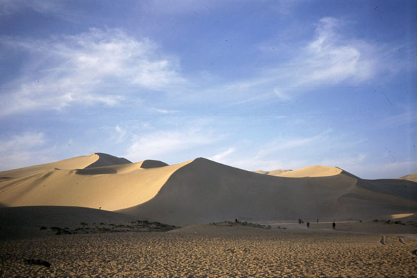
By the end of the afternoon we came to the intersection; there could be no mistake about it. We headed off the main road south to Nan An Ban, each kilometre had a kilometre marker: 1, 2, 3, ... It was here that we caught glimpse of our first wildlife: camels. There were camels leisurely grazing about the area to the left and right of us. What a sight it was. And it accorded with the fact that our route -- 313 -- bisected China's only camel preserve, in the Altun Mountains.
At kilometre marker 15 the same truck we saw earlier came behind us on its way to the village and pulled over in front of us. They told us we would reach their town at kilometre marker 21, and they left us. By kilometre marker 20 there was still no sign of a village, just some destroyed rows of structures awkwardly placed in the mountains.
At this point the spam-like tinned meat I'd dropped in my belly at noon was making me nauseous and generally ready to be off the bike. "I'm at the end of my rope," I told Brice. "It was the spam." But no sign of the town.
It is literally not until you hit the 21-kilometre marker that you come into view of Nan An Ban, hidden as it is in the Qilian Mountains. Arriving in this village, our first priority was food -- if we were going to head out into the Lop Nor desert tomorrow, we'd need to do so on the strongest foundation of calories we could possibly consume. There would be no skipping dinner tonight, and there would be no second-rate dinners; success demanded it.
We found the store in this village and began with some refreshers -- sodas and jars of preserved oranges. People were gathering around us, and one man had invited us to his home for dinner. Unfortunately, I didn't realize we'd been invited to dinner, and squandered the time drinking my soda and resting, the man waiting for us all the while. He eventually disappeared, and we missed the boat.
The manager of the village guest dormitory offered to set us up with some instant noodle, but that wouldn't due, and my partner played a key role in insisting that it wouldn't suffice. Tonight we'd have to go beg, and that's what we did. We had no choice. We found a suitable home and knocked on the door. They invited us in and agreed to feed us.
They were making lamb stew and had a huge basket full of deep-fried biscuits. We ate a generous amount of each. We also took the opportunity to ask about the road into Xinjiang -- can we do it? "Nobody goes that way," our host said. "The road has been abandoned for years. You have to go back to Aksay in Qinghai Province and that way."
Yeah, yeah, we said. But -- just for the sake of discussion -- if we did take 313 west into the desert, how far along would be the first sign of life? Our host speculated it would be a place called Xorkol, clearly marked on the map, though of no larger size than all the other stealth towns on the maps. His elderly father came home, and we put the same question forward. With greater confidence than his son, the old man said we could bet on the place called Xorkol.
"Are you going to take a gun?" the younger of the two asked. Gun? we said. What for? "There are wolves out there. Mountain lions." We laughed off the warning, though it sent a slight chill down each of our spines. To begin preparing for the trip, we asked if we could take a load of the biscuits; they gladly gave us a large bag of them.
Back at the dormitory, we got out the maps and put the same question to the manager. He agreed there'd be people at Xorkol, and we'd probably see shepherds before that, just a hundred kilometres west of Nan An Ban. Perhaps feeling ashamed that he'd asked us to eat instant noodles for dinner, the man invited us to have breakfast in his home the next morning, an appointment which would earn him the moniker "benefactor."
That night we went to bed with the decision made: the next day we'd cross into Xinjiang, westbound on 313, into the wide expanse of the Lop Nor. Xorkol is less than 300 kilometres away -- we can take enough food and water for three days. We would not even have to cycle a hundred kilometres a day. We planned to have a good breakfast tomorrow, then stop in the store for more food provisions, and head out.
|
Day 63 At 9 a.m. the village official came and led us back to his home, which we found delightful: central Asian furnishings and decor. His wife and 6-month-old daughter were lovely. We ate a ton of biscuits and drank water to our fill. We showed him our map. He said there would be shepherds 110 km west of here, and guessed there would be people at Xorkol. I asked the Kazakh woman how her village came into being -- why was there a Kazakh village hidden in the mountains of southern Xinjiang?. |
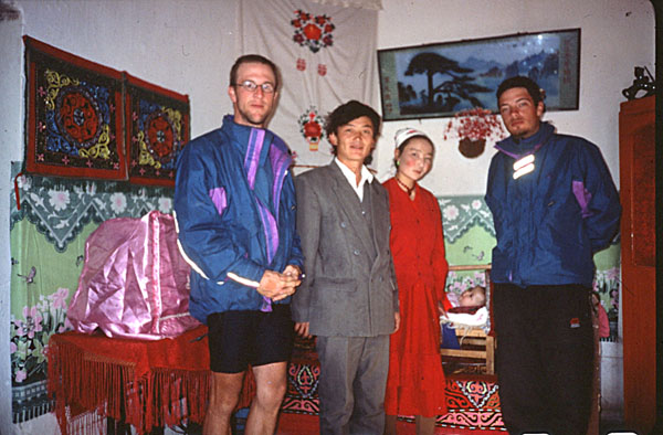 |
She explained the village leaders brought the people here in 1950 during a period of war. It was hidden and safe from the turmoil rocking Xinjiang at the time. It was indeed secluded.
We collected another bag of biscuits, and Brice went to the post office while I filled the water bladders from the official's supply -- delicious mountain water. We rendezvoused at the general store to stock up on more food: big cookie-like things and lots of candy. We also had to wait for the post office to open, watching a camel-mounted postal worker arrive shortly after we did.
By now it was getting to be late morning, so we decided to wait for the canteen to open, and take advantage of a big bowl of noodles we could get there. While there, an old woman offered to bring us steamed buns to take on the road. We latched onto the idea and asked for ten of them. We set off at 1 pm but made good time.
| About 10k down the way, 5 or 6 camels lay in the road, sunbathing. They took their time getting up, the last one doing so only when judging that we were not going to stop. We got back to highway 313 and started the daring journey west into the Lop Nor Desert. |
 |
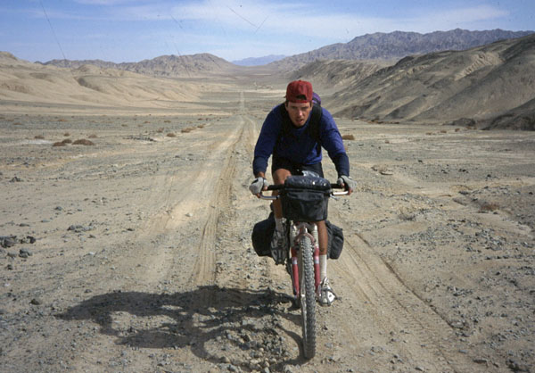
I was so charged up I could barely stand the excitement of it. What a great adventure: heading into the unknown, but full of confidence, and hardened with experience and some of the best equipment imaginable. The bikes are strong and light carbon-fibre models made by GIANT in Taiwan.
|
They are suspended in front (RockShox "Judy" DH on mine, a Japanese set on Brice's) and have bullet-proof
Shimano Deore LX components.
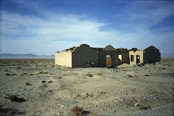
My rear rim -- the most vulnerable -- is a tried-and-tested Mavic 217. Our tyres are Tioga "Psycho" and Cheng Shin "Maxxis," both of which have been rock-solid all the way from Xi'an. Both mechanically and physically, we felt strong. The downsides were Brice's headset -- it hadn't been tested in difficult conditions since being replaced in Xi'an -- and rear rim, a Mavic 234, which had proven itself less-than-adequate under tough conditions. As for clothing, Mountain Equipment of the UK had provided us with Marathon I down sleeping bags, Ron Hill Aquabloc jacket, Ron Hill cycling shorts, Duofold polypropylene top and Ultrafleece top and trousers. It was all top-rate equipment. Sure enough, the road into Xinjiang was totally unmaintained, constantly severed by deep washouts and occasionally covered with sand that we couldn't cycle through. Even pushing the bikes through it was difficult. But I was pumped, charging hard across the desert road. The road came upon a derelict structure left to rot out there -- it was typical of the many "towns" marked on the map: nothing but a decayed shell of a house. |
 |
"I'm at the end of my rope," Brice said, though not
insisting we stop. I also though we might as well call it a day ... there were no signs of any shepherds or the
run-down buildings an old man had told us to expect. That was a cold night -- we'd found a sandy rut up a ravine, but
the wind eventually blew down it, just as hard as in the dry river bed. Very cold. I did not sleep much at all.
|
 |
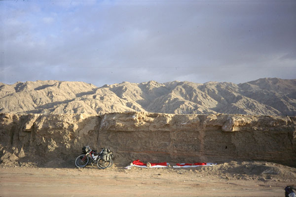
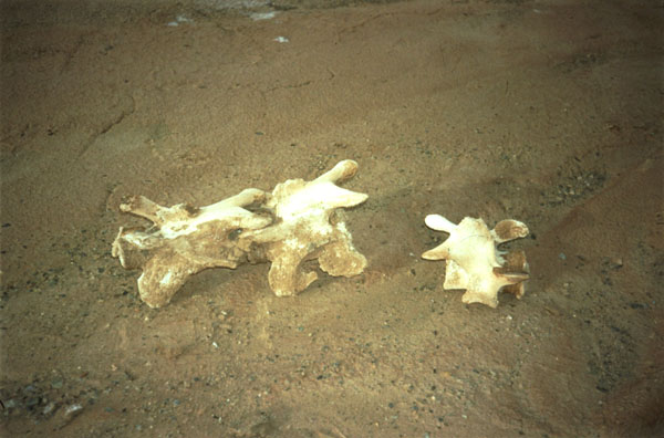
Day 64 Got up and packed our stuff. We saw the 412 marker, 3 km further ran into the shepherds! There we had a water source but filtered only a little water for fear of contamination from the sheep -- 300 of them. The shepherds told us they only stay there from September to November, then return to Nan An Ban. They said they'd never been on the road west of there ... so off we went. It was a tough climb. Major stone washouts and land slides ... tough going. "This road is going to take us forever," one of us said. We guessed we had 120 km to Xorkol -- based on what the locals said and the fact that it appeared on all three maps. Before noon, the mile markers changed shape and mileage numbers, leaving us to wonder if we were even still on 313. By noon we began ascending a series of endless plateau bowls. The views are stunning. We're way up in the mountains now. But it's mid-day, so we don't consider what night will bring. We were just enjoying ourselves, every horizon bringing something entirely new. One thing we found odd were the number of graves along the road. At least, we speculated they were graves. The place was incredibly desolate -- not even a hint of something green. But the barrenness made for quite a spectacle. By late afternoon the winds kicked up in the most violent manner, making cycling almost impossible. They blew giant gales of dust across our path, covering the entirety of some bowls. At times we would lose the road in all the chaos, desperate to find it again. The bowls repeated themselves, one after another after another. Eventually, we learned not to be too concerned with losing the road down in the bowl: just go forward to the next horizon, and the narrow corridor will assure the road will be there waiting. Brice cycled ahead each time to capture the dirt storms on film; they were incredible. With the winds accelerating, dusk brought COLD temps. The question: should we push the bikes through the night in order to stay warm, or try to go to ground? There isn't any shelter up here. It was hard to answer -- neither of us was too excited about the former option, but we also knew we would freeze if we lay still in the wind all night. I offered to check out a gully below us. It was an embankment of a dry stream, and maybe it could serve as a shelter. I was fascinated by all the camel bones strewn about the area. I asked Brice to have a look at the embankment. We decided we could hollow out a notch in the bottom of it and be somewhat protected from the wind. I did not sleep much though I was just barely warm enough in the bag with all my clothes on. |
|
Day 65 Morning brings incredibly clear sky and bright landscape. Snap a picture of our camp site. Temperature is rising. Check out camel bones scattered all around us. Take a close-up picture of one for my father. While answering nature's call, I notice a sinister dark-blue cloud looming over a mountain to our north. It was threatening and terrifying. I walked back and pointed it out to Brice. "If that thing opens up on us, it won't be rain," I speculated. "It'll be snow." Not even sixty seconds later it was over the mountain and spreading its evil tentacles over us and the plateau. Seconds later, snow began to fall... fast and hard. |
 |
|
With the sun obliterated, the temperature plummeted. I freaked out. "We're not prepared for this!" I yelled. "Don't panic, man!" Brice responded. "Let's get going." We made haste to pack up and get on the bikes, knowing we had to get the blood circulating if we wanted to get any feeling back in our fingers and toes; they were numb, and I thought about all the cases of frostbite I'd seen and read about, having grown up in Colorado. We put our cycling pants on our heads under our helmets, and socks on our hands. Getting on the bikes helped, and feeling came back to the toes. The road and surrounding area was covered with snow. The clouds parted by noon, and I felt ecstatic: "I'm keeping my toes and fingers!" I thought to myself. I hopped off the bike and gave my middle finger to the treacherous elements swirling above. "Fuck you!" I screamed with a charged, defiant emotion. "Fuck you! We made it!" I felt superhuman. "Don't do that, man!" Brice said, knowing it was foolish to declare victory so soon and tempt fate. But according to our bicycle computer, we merely had to cycle another 60 kilometres to reach Xorkol, so I felt ready to celebrate. |
 |
|
The clear skies didn't last long. As it did the day before, the wind picked up ferociously. Here we struggled to even stay upright on the cycles; sometimes it was faster to get off and push them. The sun shone on and off, but the winds never failed, and the temperature was low indeed. We cycled with most of our gear on -- including cycling shorts on our heads. In awe of the evidence of vast springtime mud flows in the bowls, we stopped for pictures of kilometre markers nearly covered in earth -- comparing buried ones to full-size ones. As the day wore on, we closed in on the 60-kilometre threshold, as recorded on the bicycle computer. Excitement brimmed in our voices. We were ready for a meal and shelter, and we'd gained altitude all day. "It should be just over that next horizon!" we speculated, referring to the town Xorkol. That horizon brought nothing but the disappointment of another kilometre-long bowl, alive only with sheets of wind-driven dust. We made an allowance for the discrepancy between the map and the bicycle computer. "The cyclometer is just a few clicks off," we reassured ourselves. |
 |
But after several more kilometres, more bowls and no hint of humanity, the expression of heightened expectation gradually left our faces, replaced by a grim foreboding. We'd eaten the majority of our provisions -- as planned, and drank a lot of our water supply. We needed that town. It represented our salvation.
"Look around, man," Brice said. "There isn't going to be any town up here." The words were blasphemy. In my refusal to accept such an outcome, I resented his outlook and put it down to alarmism. Brice saw there would be no salvation up here at 3,000 metres, and looked ahead to some possible ramifications. "My dad is a park ranger," he said. "He's pulled corpses out of situations like this before. Well, there are no park rangers up here! Nobody knows we're here! There isn't any registration book up here." Refusing to accept such a reality, I tried to argue that he was wrong -- the place would probably be just over the "next horizon."
By around 3:30, we crossed a horizon that revealed a glimmer of a structure in the far distance. "That must be the outskirts of Xorkol!" I exclaimed. "Look at that structure!"
In stiff winds, uphill and with flagging energy, we pressed forward full of hope, but gradually realized it wasn't going to be much of a structure. "Oh, man," Brice said. "I don't want to die up here. I've got too much left to do! I've got a Fulbright. Leanne. Mick. It's way too early."
We reached the structure: a collapsed house, yet again. Its walls and roof were collapsed; and trash and even clothes were strewn about it. I took the opportunity to answer nature's call. Emerging from a corner of the house, I was grabbed by Brice's words. "I think this is it, man," he said. "See that road?" he asked, pointing to a faint track leading south from us, directly to the mountains. "It's right here on the map -- a junction at Xorkol." He was right. "Notice how the road (313 -- our road) swings north a little bit ahead?" he asked, comparing the map to what we could see of the road west of us. His analysis was hard to fault, difficult as it might be to accept.
"Maybe," I said. "But maybe it's just over that next horizon? Anyway, we've got to check. Can you imagine how cold it's going to be tonight? Why spend the night here if there's shelter and food just a few kilometres away? We've got enough daylight left to at least go check." He agreed, and we set off uphill for the next ridge. It was tough going -- low energy, high winds. There were a number of false summits. Disappointment after disappointment. Under these circumstances, you cannot suffice with a 50-metre horizon -- you want to go on until you get a view of the big picture. But the reality was beginning to sink in, and I began to reassess the chances of finding something over the "next horizon."
Guessing that we may end up stuck with three more days of cycling -- without food -- my mind turned to conservation of energy. "There's no need for both of us to check this out," I told Brice. I wanted to save as many calories as possible. "Why don't I cycle ahead? I'll come back and tell you what I find." Brice reluctantly agreed, and I pressed forward. False horizon followed false horizon. I'd reach a horizon just to find it lead to another horizon -- not a view. Each time I'd say to myself, "Okay -- that next horizon is the last horizon I'm cycling to -- just one more!" and each time, I'd break that pledge and cycle to another. But the sun was plunging behind the mountains, just off to the left. Dominating the scene in that direction was a huge, white, cold mountain summit. The sun took on a frozen colour in its presence. As the afternoon retained less and less light, the wind picked up, froze, and blew stronger in my face.
I had to collect every ounce of willpower I could muster to find the energy to move the bike forward to the next horizon. "Please, God," I said. "Let there be a town up here!" I started doing deals. "If there's a town up here, I will be the most ardent spreader of your word imaginable. I will be irreversibly aware of your greatness. I will come back to the flock!"
It dawned on me that I'd been separated from Brice for over an hour. "Might he suspect I've abandoned him?" I wondered. I've got more water than he does. "Could he think that I think, 'Only one of us is going to survive -- it's going to be me'?" With these ugly thoughts occurring to me, and the cold chilling my body, I wanted to turn around and cycle downhill to Brice immediately, the wind at my back. I looked ahead: 100 or so meters to the next horizon. "One more horizon," I said.
That horizon revealed a wide expanse of high-altitude plain, bordered on the far edge by a soaring chain of mountains, covered in white. The road disappeared into the plain; how it would pass through that range of mountains was beyond me. But one thing was clear: no towns up here. It was a scene of frozen hell, and, for us, a sure road to ruin. I didn't need much time to ponder it, and the frozen wind urged me to make haste. I turned the bike around and bombed down the road, covering great distances in fleeting moments.
Closer to the bottom, I spotted Brice on his bike, heading uphill toward me. He had been carefully studying the maps, but he was chilled to the bone just sitting there, and had to get on the bike to stay warm. I reached him in jig time. "That way's suicide!" I screamed to him over the gale-force winds. "Nothing but higher mountains and snow! We've got to go back to that house for the night, and head south on that road in the morning!" He took my word for it, and we bombed back to the destroyed husk of a house, with light fading fast.
It was too cold to do anything but get immediately into the bags, but first we had to find protection from the wind. We picked out a wall, and started clearing the debris underneath it. Included were full sets of discarded clothing and even shoes. Just beyond the walls were several graves, mounds of rock, some of them obviously quite shallow and hastily dug. Where the day before they presented a curiosity, they were now a horrid scene. We cleared out the space and put our plastic sheet down and then our sleeping bags, and got in. Every piece of clothing was on us, and it was still cold. Brice recommended dropping the Ultrafleece trousers a little lower around the waist in order to use the bottom of the legs to wrap around the feet. It worked. Without question, we owe our lives to the Ultrafleece gear and sleeping bags. Though I'd hardly slept in two days, I couldn't sleep now, either. We had a lot of thinking to do. We assessed our circumstances.
--> Were we really where we thought we were? i.e. was the map right? Even if it was, were we still on 313? The road markers had totally switched before noon the previous day; and they disappeared altogether beyond this structure. How could we count on the fact we were even on the right road?
--> The road south was a giant question mark. If the road we looked at was the one on the map, it ostensibly would link-up with the main route through the region, about 40 kilometres south of us. Surely, we could find traffic on that road. The sinister aspect was the fact that the road seemed to practically disappear when it hits the mountain slope to our south; we spotted only a little fragment of it on the hillside. What if there really wasn't a road up there -- or one so marginal that we lost it -- and we wind up wandering hopelessly in the Altun Mountains? If the lack of food and water didn't kill us, the weather would.
--> The road west seemingly led to peril. I had seen the high mountains and snow covering them. If we went that direction, we wouldn't necessarily be able to survive a night up there.
We discussed these things and tentatively decided to go south -- it seemed like the quickest way out, and it wouldn't put us up against the horror I'd seen on the higher plain the day before; that was a mental obstacle I could scarcely overcome.
As I listened to Brice snore, I went over the options again in my head, waiting to hear a movement that would indicate he was awake, or semi-awake. Before dawn, he rustled, and I took the opportunity. "Brice. I've been thinking. Why don't we just cycle back east to the shepherds? We know the way; there will be no surprises. Sure, we'd have to spend another night out, but we could be there in two days. And the wind would be at our backs. And it would be downhill. But most importantly, it would mean almost certain survival."
I personally didn't prefer this option -- going east -- I favoured going south. It's not that I had a death wish; I just thought we could get out of this predicament without having to backtrack. I never doubted that we could survive for several days without food -- the limiting factor was water, and we still had enough for three days with strict rationing.
Brice also didn't like the eastern option. He couldn't bear the idea of going all the way back. What it would cost us in time and effort was unthinkable. It would mean going all the way back to Aksay and west on the main route -- 315. But there's no way we could afford such a detour time-wise, so it would require putting us and the bikes on a bus from Aksay to Ruoqiang in Xinjiang, the first sizable town on our current route. That's not the way we travel.
Since neither of us favoured going east, the choice was south or west.
The key question: which of the several "towns" marked on the map were real? Brice had studied the maps carefully that afternoon as I cycled to the last horizon. He observed the following about the route west -- assuming we were actually on route 313:
--> In 60 kilometres, the road would rise to a 3,300-metre pass and thereafter quickly lose elevation, dropping back down to the Lop Nor Desert
--> One map indicated we'd hit a water spring at 90 kilometres; this map had correctly indicated the water spring at the shepherds
--> Though there were many towns indicated on the maps, the nearest living town was going to be in the desert, either: Ruoqiang, a sure bet judging from its size on the map, reachable in four days; or Miran, reachable in three days. One map indicated a site of archaeological interest at Miran, and all the maps showed a stream that fed the oasis, raising the chances that it was a living oasis. Hence, going west would mean salvation in at most four days, and perhaps in three days.
The down-side was what I'd seen the day before: the mountains. Would the pass be snowed-in? Could we cross it and descend a considerable distance down the other side in one day? We couldn't afford to be caught up there at nightfall.
--> Going south could mean salvation in as little as 40 kilometres -- where that route would intersect the main route, 315, according to the map. The down-side was the road, which looked damned sketchy from here. Could we trust it?
This discussion was all based on Brice's recollection, since it was still pitch dark and impossible to check the maps. They would have to be consulted at first light, and we'd also have to take another gander at the road south, and make a call. Either way, time would be of the essence.
Brice pressed the illuminator on his wristwatch: 5:30 am. We laid in our bags, shivering and waiting for dawn.
